Since 2022, SeRo deployed monitoring solutions across Baltics and Central Europe, revealing daily jamming and sophisticated spoofing incidents. Data shows dramatic escalation in interference frequency, severity, and complexity requiring robust long-term countermeasures.
By Dr. Matthias Schäfer, CEO, SeRo Systems
Since 2022, SeRo Systems has been a pioneer in Global Navigation Satellite System (GNSS) interference monitoring across the Baltics and Central Europe. Our SecureTrack Secure ADS-B system was developed and launched in 2021 and its GNSS RFI monitoring capabilities have been in use since 2022. Our solution is fully aligned with EASA and ICAO recommendations and enables customers to meet industry best practices for GNSS interference awareness and response.
Working closely with air navigation service providers (ANSPs) and spectrum regulators in the Baltics, our solution was the first to be deployed in this region, providing full situational awareness for its users. Built through over 3 years of close collaboration with our partners, our solution has delivered actionable insights into jamming and spoofing threats that increasingly affect civil aviation. As a result, SeRo has the experience, the capabilities and the partnerships necessary to be a leader in airspace resilience.
Highlights
• Real-time detection and alerts for GNSS jamming and spoofing, paired with powerful tools for in-depth analysis.
• All-in-one platform combining ground-based RFI monitoring with ADS-B and multilateration-based airspace surveillance.
• Fully aligned with EASA and ICAO recommendations, supporting industry best practices.
• Accurate threat localization via a patent-pending jammer detection method, enabling actionable responses.
Escalating Threats to Airspace Safety
GNSS interference poses a growing risk to aviation, ranging from unintentional small-scale disruptions to targeted large-scale electronic warfare. While some interference stems from low-cost devices and criminal activity (such as trafficking), much of the persistent disruption we observe originates from coordinated, high-power jamming and spoofing due to military exercises and electronic countermeasures.
Since mid-2023, SeRo has documented a sharp increase in jamming activity. Our ground-based GRX receivers have been deployed throughout Central Europe and the Baltics, creating a comprehensive sensor network that enables real-time detection of jamming across GNSS frequencies. In certain areas, the interference affects GNSS frequencies within the upper L-band (L1, E1, G1) and the lower L-band (L5, E5, G3), both of which are critical for satellite-based positioning, navigation and timing (PNT), increasing the risk of widespread disruption. This interference has become particularly severe over Estonian, Finnish, Polish, Lithuanian, and Latvian airspace.
The Rise of Spoofing
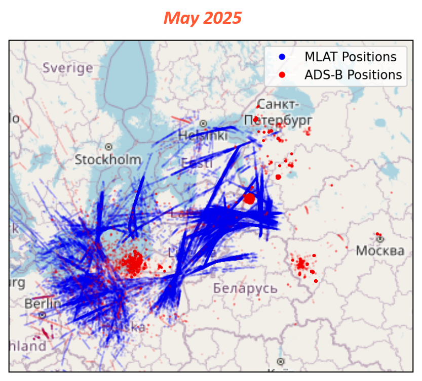
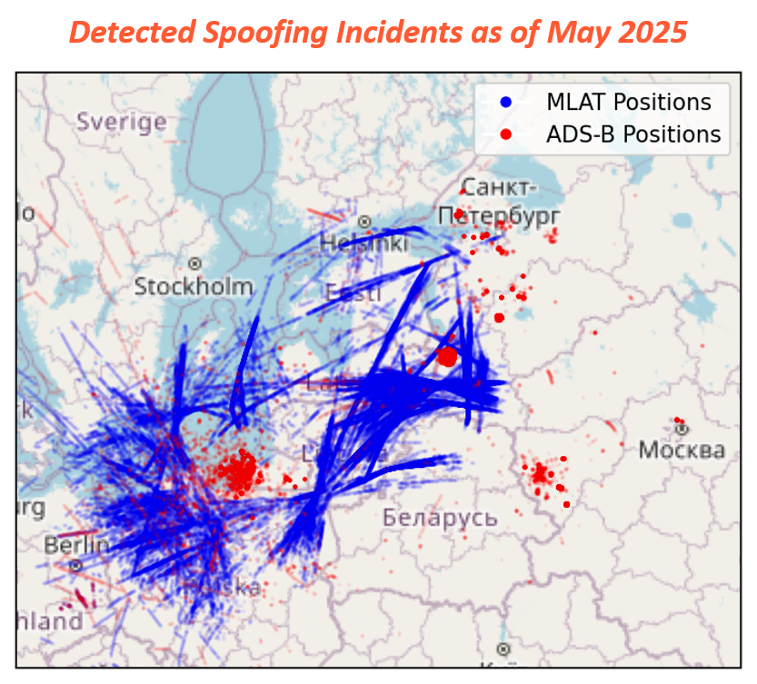
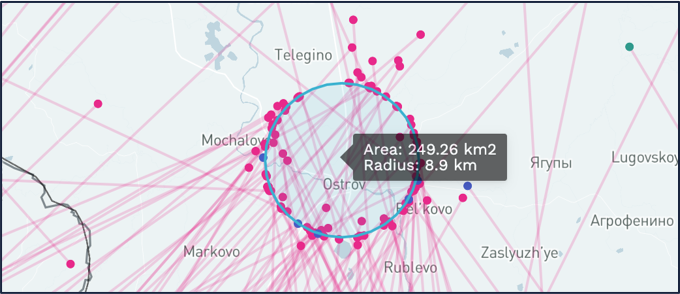
By late 2023, spoofing activity emerged as an equally pressing issue in the Baltic region. Aircraft began reporting false positions, with spoofed positions initially centered near Smolensk before rapidly expanding to broader areas along the border and Kaliningrad. Over 22,500 flights have been affected since then—undermining aviation safety and operational efficiency. During our analysis, we identified and documented multiple incidents of “circle spoofing” where false GPS signals create simulated circular flight paths with a 1 to 10 kilometer radius.
Our multilateration-based system provides the true aircraft positions while aircraft are under jamming and spoofing attacks, enabling full situational awareness and accurate in-depth incident analysis. This capability is essential in understanding which airspace is affected, how spoofing signals behave, and where mitigation measures are most urgently needed.
Localizing the Threat
To address the critical need for source identification, we developed a patent-pending jammer localization method that uses ADS-B-based analysis to pinpoint signal origins to within a few tens of kilometers. This innovation allows stakeholders to move beyond mere detection and take strategic action.
Robust Reporting for Critical Data Analysis
Our intuitive and easy-to-use reporting functions are driven by our customers' experience and their needs. The system offers multiple formats that our customers can configure, download and seamlessly integrate into their existing tools and reporting.
The platform transforms technical data into operational awareness. Complex jamming and spoofing situations are distilled into clear, accessible, and actionable insights, enabling users to understand and respond effectively to emerging threats. Our user interface is highly customizable, offering advanced data filtering and browsing functions that allow users to tailor their view and focus on what matters most to their specific use case. Whether monitoring regional activity or conducting forensic investigations, users can adapt the system to meet their workflow. To support seamless integration, standard data export formats such as CSV, JSON, and KML are available, ensuring compatibility with established tools and reporting chains Additionally, our comprehensive data archive provides access to all available levels of data granularity: from raw individual transponder signal data to aggregated ADS-B and MLAT positional information. This full-spectrum access allows for everything from real-time monitoring to deep-dive post-event analysis.
Real-Time Detection for Real World Problems
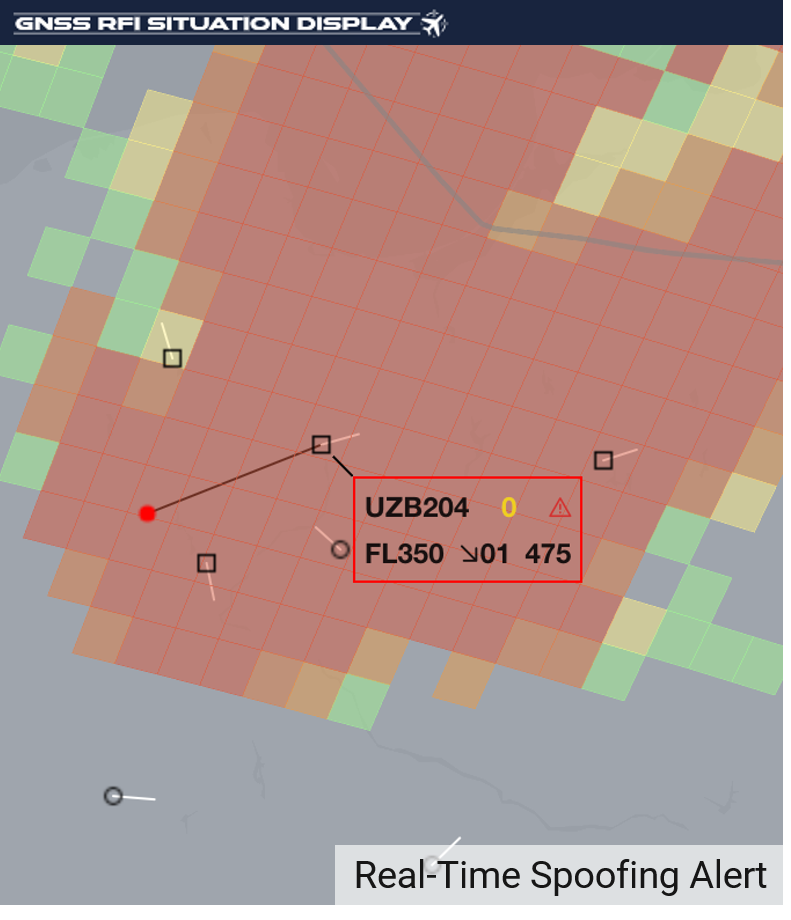
Through our collaboration with ANSPs and spectrum regulators, it became clear that they would greatly benefit from enhanced functionality and real-time alerts. To answer the call, SeRo developed our GNSS RFI Situation Display (GRSD). Leveraging our vertically integrated receiver network, the GRSD uses its anomaly detection algorithm and high-precision multilateration (MLAT) to monitor the airspace. The color-coded live traffic Real-Time GNSS Interference Intensity Map identifies current interference zones, while the AI-supported short-term interference alerting feature predicts when aircraft will enter the zone and be subject to interference. The system also generates alerts in cases of spoofing, automatically highlights the impacted aircraft and indicates both the spoofed and the correct aircraft position. When combined with our SecureTrack Secure ADS-B solution, users get instant alerts combined with historical data for the actionable intelligence they need to make crucial decisions.
A Proven Path Forward
Aviation organizations agree that combatting this threat requires accurate and timely information about the extent of the interference. EASA and ICAO have consistently emphasized the importance of monitoring, reporting and collaboration to understand and mitigate GNSS interference. In recent publications, both organizations urge operators to report GNSS outages and anomalies and encourage coordination among aviation stakeholders, including ANSPs, aircraft operators, military organizations and industry to develop mitigation strategies. Unfortunately, pilot reporting rates are declining, with as little as 5% of incidents being reported to authorities in some regions.
While future technologies like authenticated GNSS signals or more robust antenna technologies promise stronger spoofing and jamming resistance, these changes will take years—if not decades—to reach broad adoption. The short-term solution lies in deploying comprehensive, real-time monitoring systems to detect interference, alert stakeholders, and support compliance. Our GNSS RFI monitoring solution is fully aligned with the latest ICAO and EASA recommendations, helping to ensure compliance with international best practices for resilient and secure operations. The widespread use of these technologies, along with national and international collaboration is the best line of defense.
By working together and armed with the right tools and the right data, we can build more resilient airspace operations and ensure continued safety in a time of increasing interference.
If you are interested in setting up a trial or would like a demo of our software, please contact us.


